

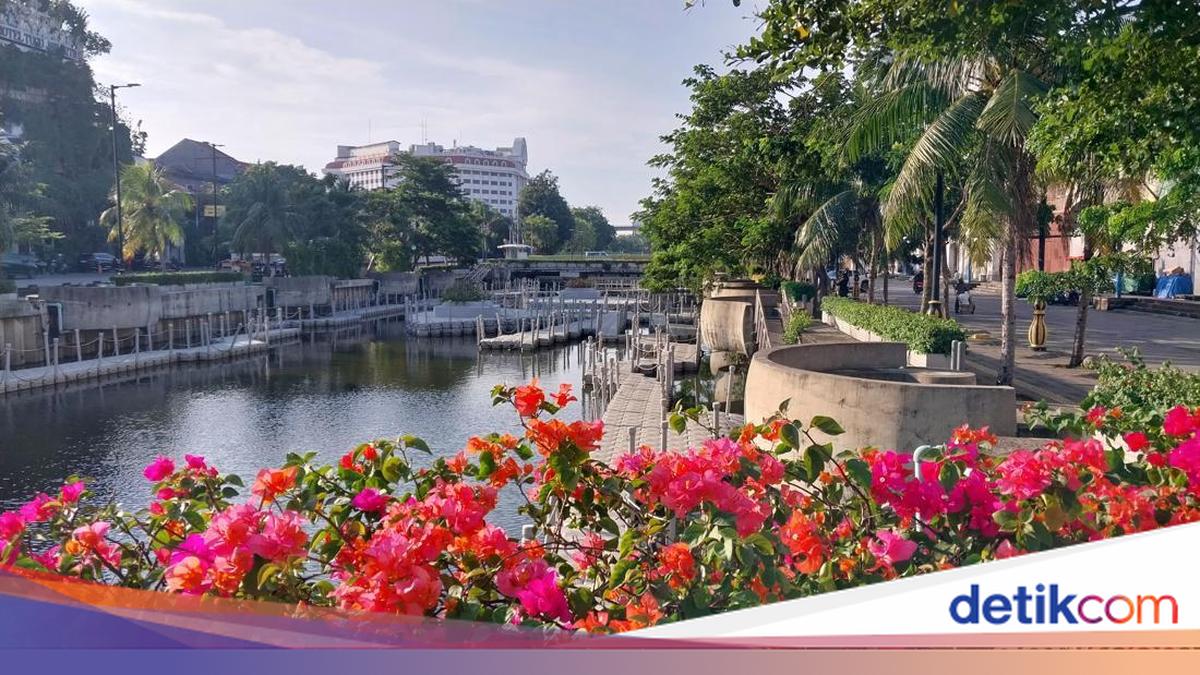
The journey through Jakarta’s Old Town, known locally as Kota Tua, remains incomplete if a traveler only navigates the perimeter of Fatahillah Square. By venturing slightly westward, one encounters the storied banks of Kali Besar, a waterway that serves as much more than a mere drainage system or a scenic backdrop. Once known as De Groote Rivier during the Dutch colonial era, this river stands as a testament to the meticulous urban planning of the 17th century. On Tuesday, April 7, 2026, Gilang Ramadhan, a guide from the Free Guided Tour UPK Old Town, led an exploration titled "Oud Batavia en Omstreken: Then & Now," providing a deep dive into the golden age of Batavia and the architectural philosophy that shaped the region.
Today, the charm of the past is preserved with remarkable clarity. The European-style architecture lining the riverbanks has undergone significant revitalization, transforming the area into a vibrant pedestrian zone. This modernization effort has not erased history but has instead highlighted the "Ideal City" concept that served as the blueprint for Batavia’s inception. Inspired by the layout of Amsterdam, the Dutch colonial administrators envisioned a settlement that was both aesthetically pleasing and strategically formidable.
The Blueprint of the Ideal City: Amsterdam of the East
The development of Batavia was not an accidental expansion but a calculated engineering feat. According to historical records and the insights shared by the UPK Old Town guides, the "Ideal City" concept was predicated on three non-negotiable criteria designed to ensure security, social order, and economic efficiency.
First, the city was required to be a fortified enclave. In an era of constant maritime conflict and local resistance, the Dutch East India Company (VOC) mandated that Batavia be surrounded by high walls and bastions. Second, the residential and commercial blocks were designed with strict symmetry. The housing followed a grid-like pattern, ensuring that the city remained organized and easily navigable for administrative purposes. Third, and perhaps most crucially, the city was integrated with an extensive network of canals.
These canals were not intended for aesthetic pleasure alone; they were the lifeblood of Batavian logistics. Much like the waterways of the Netherlands, the canals of Batavia served as primary transportation arteries. Small and medium-sized merchant vessels could navigate directly from the sea into the heart of the city, bringing spices, textiles, and colonial goods to the doorsteps of warehouses. Larger vessels, such as the iconic galleons, remained anchored at the nearby Port of Sunda Kelapa, while lighters and smaller boats ferried cargo through the Kali Besar.
Kali Besar as the Colonial Central Business District
The high volume of maritime traffic cemented Kali Besar’s status as the Central Business District (CBD) of ancient Batavia. Because of its prestigious reputation and economic importance, the construction of buildings along the river was governed by rigorous regulations. The "Waterfront City" concept was strictly enforced, requiring all structures to face the river.
"Buildings in the vicinity of the river were required to face forward toward the water; they were never allowed to turn their backs on the canal," explained Gilang Ramadhan during the tour. This architectural mandate ensured that the river remained the focal point of public and commercial life. While commercial buildings adhered to this rule, exceptions were made for government-related structures or religious institutions, such as churches, which were traditionally oriented toward the central town square or "alun-alun."
This planning philosophy created a grand corridor of facades that showcased the wealth and power of the VOC. Today, walking along the pedestrian paths of Kali Besar feels akin to traversing a time capsule, where the functional history of each building tells a story of global trade and cultural synthesis.
Architectural Landmarks: A Timeline of Stone and Brick
The stretch of Kali Besar is home to several of Jakarta’s most significant historical assets. Each structure represents a different chapter in the city’s evolution, from the height of the VOC’s power to the early years of Indonesian independence.
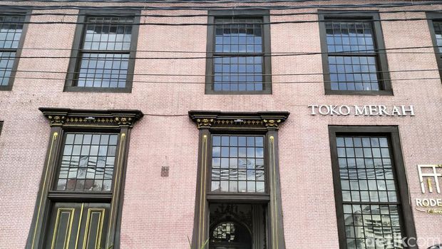
1. Toko Merah (The Red Shop)
The most visually striking building on the banks of Kali Besar is undoubtedly Toko Merah. Distinguished by its deep red brickwork, this mansion was originally the residence of Gustaaf Willem Baron van Imhoff, a prominent VOC official who later became the Governor-General. Built in 1730, the structure is actually a combination of two large houses, evidenced by its twin main entrances. In its heyday, the interior could be partitioned to accommodate two separate families, reflecting the high-density luxury of colonial elite living. Its name, "Toko Merah," was adopted much later in the 19th century when the building functioned as a retail outlet owned by a Chinese merchant.
2. The Former Standard Chartered Building (Bank Mandiri)
Located at a strategic corner, this building is easily identified by its majestic dome. Constructed around 1912, it served as the office for the Standard Chartered Bank during the late colonial period. The architecture reflects the "Nieuwe Zakelijkheid" or Dutch Modernist style, which began to move away from heavy ornamentation toward more functional, clean lines while maintaining a sense of grandeur. Following the nationalization of Dutch assets and the eventual merger of several state banks in 1998, the building is now an asset of Bank Mandiri.
3. The Legacy of Frederich Silaban
One of the most intriguing facts about the Kali Besar area is that its architectural heritage is not exclusively Dutch. Amidst the colonial facades stands a magnificent banking building from the 1950s, designed by the legendary Indonesian architect Frederich Silaban. Silaban, who is best known for designing the Istiqlal Mosque and the National Monument (Monas), brought a post-independence modernist touch to the district. His work in Kali Besar features the sharp, clean geometric lines characteristic of his style, serving as a bridge between Batavia’s colonial past and Indonesia’s sovereign future.
4. Jasa Raharja Building (Formerly Eka Karya)
This building originally housed a marine and fire insurance company during the colonial era. Given the high risks associated with maritime trade and the wooden structures of early Batavia, insurance was a cornerstone of the local economy. After Indonesia gained independence, the company was nationalized and became Eka Karya, which eventually evolved into the state-owned insurance firm Jasa Raharja.
5. KPP Tambora and Bahtera Adiguna
Further down the river, the KPP Tambora building stands as a massive white structure dating back to the 1800s. Originally used for large-scale trading operations, its elongated design was intended to maximize storage and office space. Today, it has been repurposed as a Tax Service Office. Nearby, the Bahtera Adiguna building reminds visitors of the area’s logistical roots; it served as a vital warehouse for shipping and maritime equipment, built with the robust materials necessary to withstand the humid, salty air of the waterfront.
Revitalization and Modern Implications
The transformation of Kali Besar reached a turning point in 2018, when the Jakarta Provincial Government initiated a major revitalization project in preparation for the Asian Games. The project involved cleaning the waterway, installing a floating filtration system, and creating wide, paved walkways inspired by the urban canals of Europe.
This revitalization has had a profound impact on Jakarta’s urban identity. For decades, the city’s rivers were often viewed as neglected backyards or flood hazards. By returning to the "Waterfront City" philosophy, the city has successfully reclaimed the river as a public space. Data from the Jakarta Tourism Office suggests that since the revitalization, visitor numbers to the western side of Kota Tua have increased by nearly 40%, easing the congestion at Fatahillah Square and distributing economic benefits to a wider range of local vendors and businesses.
Analysis of this urban planning shift suggests that Kali Besar serves as a model for "adaptive reuse." Rather than demolishing old structures, the city has found ways to integrate 18th-century architecture with 21st-century tourism needs. This approach not only preserves cultural heritage but also provides an educational platform for younger generations to understand the complexities of Jakarta’s history—including the darker periods of colonial exploitation and the triumphs of national development.
A Vision for the Future
The preservation of Kali Besar is part of a larger ambition to have Jakarta’s Old Town recognized as a UNESCO World Heritage site. While challenges remain—such as maintaining water quality and managing the subsidence issues that plague North Jakarta—the current state of Kali Besar offers a glimmer of hope. It proves that with thoughtful intervention, history does not have to be a static museum piece; it can be a living, breathing part of the modern metropolis.
As the sun sets over the red bricks of Toko Merah and the shadows of the Dutch domes lengthen across the water, Kali Besar offers a rare moment of tranquility in the heart of Indonesia’s busiest city. For the traveler, it is a place to reflect on the passage of time. For the citizen, it is a reminder that the "Ideal City" is not just a relic of the past, but a goal that requires continuous effort, planning, and respect for the layers of history that define Jakarta. Through the efforts of guides like Gilang Ramadhan and the ongoing commitment to urban conservation, the story of De Groote Rivier continues to flow, connecting the Batavia of yesterday with the Jakarta of tomorrow.
