
The United States National Aeronautics and Space Administration (NASA) has intensified its spaceborne surveillance of the ongoing volcanic activity at Mount Anak Krakatau, utilizing a suite of advanced Earth-observing satellites to capture high-resolution imagery and atmospheric data. The continuous monitoring effort, which began in early September 2026, highlights the international scientific interest in the volatile Sunda Strait volcano. Meanwhile, Indonesian authorities have reported a transition in the volcano’s eruptive style, though the national alert status remains elevated as deep-seated magma movements continue to pose potential hazards to aviation and coastal communities.
Advanced Satellite Observations Capture Volcanic Plumes
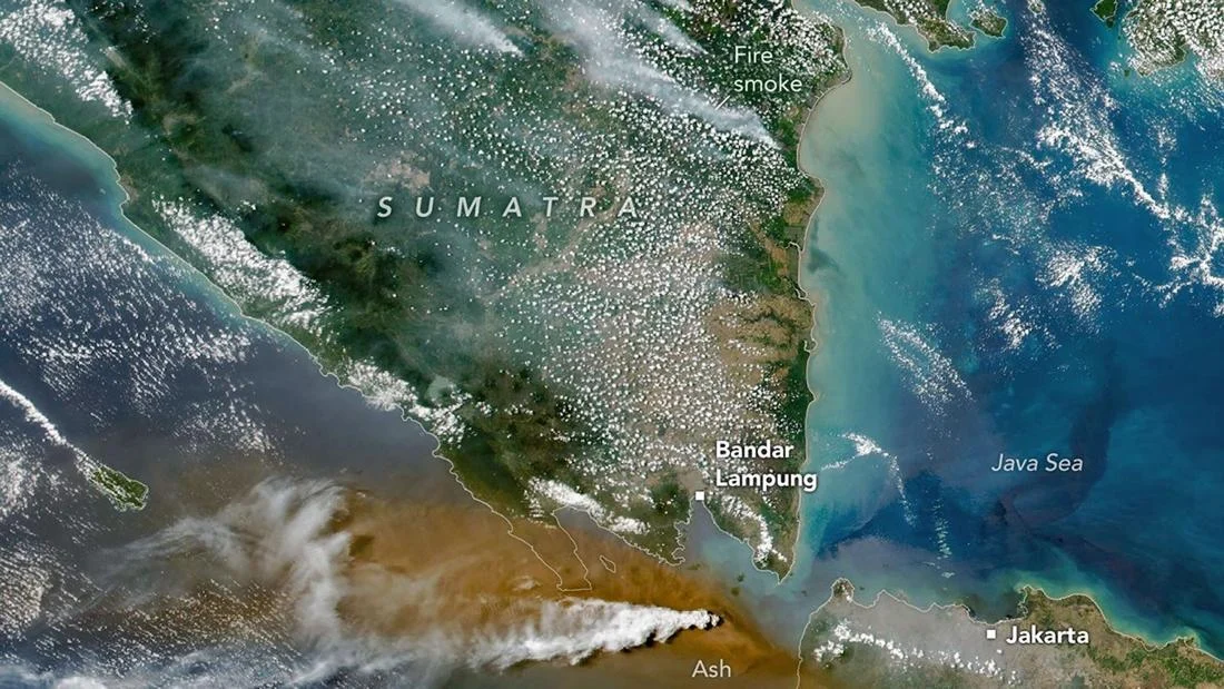
According to data released by NASA’s Earth Observatory, multiple satellite instruments have been deployed to analyze the composition and dispersion of the volcanic materials spewed by Mount Anak Krakatau. On September 5, 2026, the Operational Land Imager (OLI) aboard the NASA-USGS Landsat 8 satellite captured detailed visual evidence of the eruption. The imagery revealed distinct plumes of white volcanic gas billowing above a dense, brownish layer of ash clouds hovering close to the summit.
Complementing the Landsat 8 findings, data captured on the same day by the Visible Infrared Imaging Radiometer Suite (VIIRS), an instrument flying aboard the NOAA-20 weather satellite, confirmed the coexistence of white water vapor and sulfur-laden gas alongside heavier ash concentrations. These multi-spectral observations allow volcanologists to differentiate between various atmospheric components, providing critical insights into the intensity and height of the eruption column.
Further analysis of the atmospheric layers over the Sunda Strait was conducted using aerosol index measurements at the 380-nanometer wavelength. NASA data recorded aerosol index values ranging from 10 to 20—and occasionally higher—represented visually on data maps by deep yellow, orange, and red gradients. In atmospheric science, the aerosol index correlates directly with aerosol optical depth, signaling a substantial elevation in the concentration of fine particulate matter suspended in the atmosphere. High aerosol index values of this magnitude unequivocally confirm the dense presence of volcanic ash within the eruption plume, contrasting sharply with baseline atmospheric conditions where lower index values denote clearer skies and minimal particulate suspension.
In addition to particulate matter, NASA’s atmospheric sounding instruments tracked the dispersion of sulfur dioxide ($textSO_2$) columns stretching into the upper troposphere and lower stratosphere. The satellite mapping displayed high concentrations of $textSO_2$ through stark color gradients shifting from deep blue to bright white, underscoring the significant degassing processes accompanying the magmatic activity at Mount Anak Krakatau.
Current Volcanic Status and Geological Shifts
While space agencies monitor the atmospheric footprint, domestic geological authorities remain on the ground maintaining round-the-clock vigilance. The Geological Agency under the Indonesian Ministry of Energy and Mineral Resources (KESDM) issued a comprehensive update on September 11, 2026, detailing a notable transition in the physical behavior of Mount Anak Krakatau.
According to the Geological Agency, the volcano’s activity has gradually subsided from violent explosive phases into a Strombolian style of eruption. Characterized by periodic bursts of gas-driven explosions, Strombolian activity typically expels incandescent lava fragments, volcanic bombs, and localized ash plumes in the immediate vicinity of the active crater.
Despite this apparent downgrade in surface violence, the Geological Agency emphasized that the national threat level for Mount Anak Krakatau remains at Level III (Siaga, or Standby). Seismic monitoring instruments have recorded a shift in surface seismic signatures, specifically noting an increase in low-frequency earthquakes and hybrid seismic events. More critically, volcanologists observed an overall elevation in volcanic tectonic earthquakes compared to baseline historical averages.
This sustained seismicity beneath the edifice indicates that magma continues to be actively supplied from deeper crustal reservoirs. The persistent influx of fresh magma suggests that the plumbing system beneath Mount Anak Krakatau remains pressurized, meaning the threat of sudden, more intense eruptive phases cannot be discounted in the near future.
Historical Context and Chronology of the Sunda Strait Volcano
Mount Anak Krakatau, which translates to the "Child of Krakatoa," occupies a legendary and perilous position in global volcanology. Emerging from the caldera of the infamous 1883 cataclysmic eruption of the original Krakatoa—which claimed tens of thousands of lives and altered global climate patterns—the emergent cone has been growing rapidly since its appearance above sea level in 1927.
The volcano has experienced numerous eruptive cycles throughout the 20th and 21st centuries. A major turning point in its modern history occurred in December 2018, when a massive flank collapse triggered a deadly tsunami along the coastal regions of Banten and Lampung, resulting in hundreds of fatalities and extensive property damage. Following that collapse, the volcanic edifice lost a significant portion of its height, only to continuously rebuild itself through frequent Strombolian and Vulcanian eruptions over the subsequent years.
The current 2026 eruptive phase represents the latest chapter in the relentless construction and deconstruction cycle of the young volcanic island. Because of its unique maritime setting and history of sudden structural failure, any significant activity at Anak Krakatau immediately triggers heightened surveillance protocols from both Indonesian institutions and international partner agencies like NASA and the Japan Aerospace Exploration Agency (JAXA).
Implications for Aviation and Maritime Navigation
The intersection of space-based aerosol tracking and ground-based volcanology plays a vital role in mitigating the risks posed to regional infrastructure, particularly civil aviation and maritime traffic. Volcanic ash clouds pose severe hazards to commercial aircraft; microscopic silicate particles can melt inside jet engines, adhering to turbine blades and leading to catastrophic engine failure.
The high concentrations of sulfur dioxide and particulate matter detected by Landsat 8 and NOAA-20 provide immediate data inputs for Volcanic Ash Advisory Centers (VAACs), allowing aviation authorities to issue timely rerouting warnings to airlines traversing the busy airspace between Java and Sumatra. Similarly, maritime operators in the Sunda Strait are advised to maintain a safe exclusion zone around the active cone, as sudden Strombolian explosions can hurl incandescent pyroclastic material and ballistic projectiles into surrounding waters without advanced warning.
Official Responses and Ongoing Preparedness
Indonesian disaster management agencies, including the National Board for Disaster Management (BNPB) and local regional disaster mitigation offices (BPBD), continue to coordinate closely with the Center for Volcanology and Geological Hazard Mitigation (PVMBG). Public safety advisories remain in effect, mandating that tourists, fishermen, and residents stay outside the established exclusion radius—typically set at a minimum of five kilometers from the active crater.
Emergency response teams have reviewed evacuation protocols for vulnerable coastal populations in the Sunda Strait region, ensuring that early warning systems installed after the 2018 tsunami remain fully operational. While the transition to Strombolian activity has brought a temporary reprieve from continuous ash rain on nearby shores, authorities stress that complacency is unwarranted given the active magma resupply indicated by deep seismic data.
As satellite observations from NASA continue to stream into research facilities worldwide, the synergy between orbital remote sensing and terrestrial monitoring demonstrates a robust framework for modern volcanic risk management. The continuous tracking of aerosol dispersion and $textSO_2$ plumes ensures that scientists and disaster responders remain well-equipped to anticipate escalations at one of the world’s most closely watched geological laboratories.
