
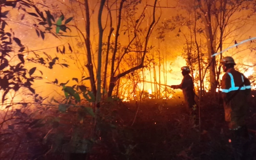
The National Disaster Management Agency (Badan Nasional Penanggulangan Bencana, or BNPB) has reported a concerning escalation in environmental threats following a wave of forest and land fires (kebakaran hutan dan lahan, commonly known as karhutla) across multiple regions of the archipelago. According to official figures released by the agency, approximately 62 hectares of land were ravaged by flames within a single 24-hour reporting window spanning from Saturday, September 26, 2026, to Sunday, September 27, 2026. The widespread environmental damage has heavily impacted four critical provinces, underscoring the persistent vulnerability of Indonesia’s diverse landscapes to seasonal blazes and sudden outbreaks of fire.
The localized disasters, which struck both forested terrain and agricultural properties, were officially recorded across the provinces of Central Sulawesi, South Sulawesi, Bali, and East Java. This multi-regional outbreak has once again brought the perennial challenge of fire management, mitigation, and rapid disaster response to the forefront of national attention. Disaster management authorities, regional emergency response teams, and local governments have been placed on heightened alert to contain active blazes, prevent secondary outbreaks, and safeguard nearby residential settlements from encroaching smoke and flames.
Chronology of the Outbreaks: A Region-by-Region Breakdown
The string of incidents began in the early hours of Saturday, September 26, 2026. The first major event was documented in Central Sulawesi, specifically striking Wanamukti Utara Village, located within the Bolano Sub-district of Parigi Moutong Regency. According to incident reports, the fire ignited at approximately 01:00 Central Indonesia Time (WITA). The sudden emergence of the blaze in the dead of night caught local residents off guard, though the exact catalyst behind the ignition remains shrouded in uncertainty.
Berton SP Panjaitan, the Acting Head of the Data, Information, and Disaster Communication Center at BNPB, issued a formal written statement on Sunday, September 27, 2026, shedding light on the severity of the initial strike. "An expanse of land spanning three hectares was consumed by the red rooster in this incident," Panjaitan stated, utilizing a common Indonesian idiom for raging fires. Despite the swift and destructive nature of the flames, local authorities confirmed that no immediate civilian casualties were reported, largely owing to the relative distance between the burning zone and densely populated residential areas.
Following the outbreak in Parigi Moutong, emergency protocols were activated without delay. The Regional Disaster Management Agency (Badan Penanggulangan Bencana Daerah, or BPBD) of Parigi Moutong Regency immediately mobilized its personnel to the scene. In a coordinated effort to suppress the fire, BPBD officials established direct communication and collaboration with local village apparatuses, sub-district administrators, and community volunteers. Field teams engaged in intensive tactical maneuvers, executing localized suppression operations and creating structural firebreaks—known locally as penyekatan—to halt the lateral spread of the flames and ensure the fire did not breach the perimeter toward inhabited lands.
While the Central Sulawesi incident marked the temporal beginning of the weekend’s disaster cycle, subsequent reports from BNPB confirmed that similar emergencies manifested simultaneously across the other three targeted provinces. Although individual spot fires varied in scale and intensity, their collective toll contributed heavily to the staggering 62-hectare aggregate documented by national monitors within the single-day timeframe.
Supporting Data and the Macro-Landscape of Karhutla
To understand the gravity of a 62-hectare loss within a 24-hour period, experts evaluate these figures within the broader context of Indonesia’s national climate and disaster patterns. Forest and land fires in Indonesia have historically represented a complex socio-environmental challenge, driven by a confluence of climatic anomalies, human activity, and geographical vulnerabilities.
While mega-fires typically capture international headlines during prolonged dry spells or severe El Niño phases—which severely suppress rainfall and desiccate peatlands—isolated outbreaks of this magnitude during transitional weather periods highlight the omnipresent risk of localized ignition sources. These ignition sources frequently range from unregulated agricultural clearing practices and discarded cigarette butts to unattended campfires and spontaneous combustion under high-temperature conditions.
The geographical distribution of the September 2026 incidents across Central Sulawesi, South Sulawesi, Bali, and East Java illustrates that karhutla is no longer confined to the traditional high-risk provinces of Sumatra and Kalimantan. Instead, eastern and central regions of the archipelago, characterized by expansive savanna lands, hilly terrain, and vulnerable dry-season vegetation, are increasingly susceptible to rapid fire propagation. The 62 hectares destroyed during this specific weekend serve as a micro-indicator of the immense pressure placed on local ecosystems and the logistical strain experienced by provincial disaster management units.
Institutional Response and Inter-Agency Coordination
The containment of the widespread blazes relied heavily on the multi-tiered architecture of Indonesia’s disaster response system, anchored by BNPB and executed on the ground by provincial and regency-level BPBD offices. When the fires broke out across the four provinces, the response protocol followed a strict chain of command designed to prioritize human safety, asset protection, and environmental preservation.
Upon receiving distress signals and field observations from local informants, BPBD units acted as the frontline operational command. In Parigi Moutong and comparable disaster zones, regional teams coordinated heavy equipment deployment, water-tanker routing, and manual suppression teams. Because many of the affected zones featured rugged terrain that hindered the access of conventional fire trucks, responders heavily relied on manual containment techniques. These included clearing dry underbrush, beating back flames with specialized flappers, and wetting down peripheral vegetation to create damp firebreaks.
Furthermore, BNPB’s central office maintained a continuous monitoring loop, aggregating incoming field data from Sulawesi, Bali, and Java to assess whether the cumulative scale of the fires necessitated the deployment of national aerial firefighting assets, such as water-bombing helicopters. While the localized suppression efforts successfully managed to corral the flames before they expanded into catastrophic regional conflagrations, the situation underscored the critical need for continuous capacity-building among local emergency responders.
Broader Implications and Socio-Environmental Analysis
The occurrence of multi-province forest and land fires carries profound implications for public health, economic stability, and long-term environmental sustainability. Even when individual fire incidents appear relatively localized—such as the three-hectare blaze in Parigi Moutong—the cumulative atmospheric release of carbon dioxide and particulate matter contributes to regional air pollution. Smoke from karhutla frequently contains hazardous fine particulate matter (PM2.5), which poses severe respiratory risks to vulnerable populations, including children, the elderly, and individuals with pre-existing cardiopulmonary conditions.
Economically, the recurring destruction of dozens of hectares of land exerts direct pressure on local agrarian communities. In regions where smallholder farming, livestock grazing, and community forestry overlap, the loss of land translates directly to diminished livelihoods, soil degradation, and the destruction of local biodiversity. The topsoil stability of fire-stricken terrain is severely compromised, raising the long-term risk of soil erosion, landslides during subsequent seasonal downpours, and diminished agricultural productivity.
From a regulatory standpoint, these incidents reinforce the urgent necessity of proactive prevention campaigns rather than purely reactive suppression strategies. Environmental analysts emphasize that public education regarding zero-burn land preparation techniques, strict law enforcement against illegal land clearing, and the establishment of community-based early warning systems are vital components in breaking the cycle of seasonal fires. The integration of real-time satellite monitoring with community surveillance networks remains one of the most effective defenses against the sudden eruption of unmonitored blazes.
As Indonesia navigates the complexities of changing weather patterns and demographic pressures on natural landscapes, the events of September 26-27, 2026, stand as a clear reminder of the vigilance required across all levels of government and society. With BNPB maintaining its rigorous tracking systems and local BPBD units remaining on permanent standby, the ongoing fight against karhutla demands sustained resource allocation, inter-agency synergy, and an unwavering commitment to environmental protection.
