
The vantage point of space provides a unique perspective that transforms our understanding of the planet. From the deepest marine trenches to the most arid deserts, high-resolution satellite imagery has become an indispensable tool for geologists, environmentalists, and researchers. By capturing light across various spectra—often invisible to the human eye—these orbital platforms reveal the complex history of Earth’s surface, the fragility of its ecosystems, and the volatile nature of its tectonic foundations. Recent imagery, processed and analyzed by global observation agencies, highlights ten distinct geographical features that underscore the diversity of the terrestrial landscape.
The Great Blue Hole: A Relic of the Last Ice Age
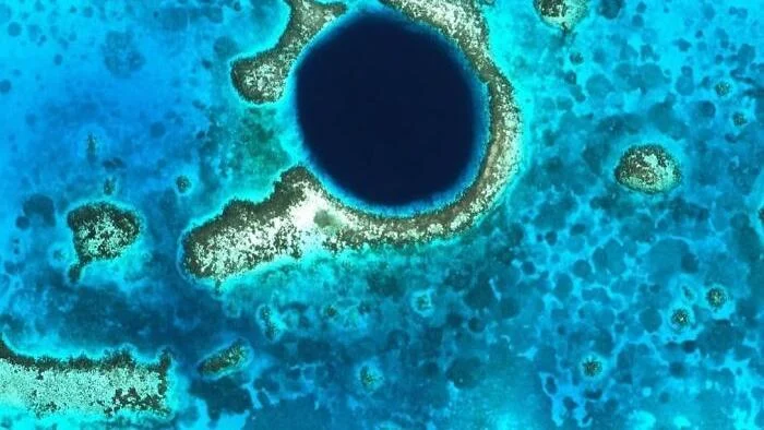
Located approximately 70 kilometers off the coast of Belize in the center of Lighthouse Reef, the Great Blue Hole is one of the world’s most recognizable marine features. Measuring roughly 300 meters in diameter and reaching depths of 125 meters, this near-perfect circular sinkhole serves as a geological time capsule.
Geologists have determined that the structure originated during the Quaternary glaciation, a period characterized by significantly lower sea levels. Originally a dry limestone cave system formed through karst processes, the structure was submerged as the ice sheets melted and sea levels rose globally. Today, the site is recognized not only as a UNESCO World Heritage site but also as a premier destination for marine biology research. Analysis of stalactites found within the hole has provided scientists with critical data regarding climate fluctuations over the past 150,000 years, offering a paleoclimatic record that informs modern climate change models.
The Hara Forest: A Mangrove Sanctuary in the Persian Gulf
Between the Iranian island of Qeshm and the mainland lies the Hara Forest, an expansive mangrove ecosystem that thrives in the saline conditions of the Persian Gulf. This area is the largest mangrove habitat in the region, characterized by complex, branching tidal channels that shift with the lunar cycles.
Since its designation as a protected area in 1972, the Hara Forest has served as a critical stopover for migratory bird species, including flamingos, pelicans, and various species of storks. The ecosystem is also vital for the survival of the endangered green sea turtle, which utilizes the nutrient-rich waters for foraging. From an environmental management perspective, the forest acts as a natural carbon sink and a biological buffer, protecting the coastline from erosion and storm surges—a function that has become increasingly important as the Persian Gulf experiences rising water temperatures.
Seismic Reawakening in the Bismarck Sea
The volatile nature of the Pacific "Ring of Fire" was underscored on May 8, 2026, when a series of low-magnitude earthquakes beneath the Bismarck Sea signaled the reactivation of a previously dormant volcanic structure. Located 125 kilometers southeast of Manus Island, the site—identified by scientists as Titan Ridge—demonstrated rapid escalation.
Within 24 hours of the initial seismic tremors, satellite sensors detected massive steam plumes rising nearly 3,000 meters above sea level. Volcanologists monitoring the event noted that the sudden discharge of volcanic gases and ash indicates a significant shift in the subduction dynamics of the Bismarck microplate. This event serves as a reminder of the submarine volcanic activity that often goes unnoticed until surface-level manifestations occur. Continuous monitoring by regional seismic networks is currently underway to assess the potential for long-term volcanic instability in this maritime corridor.
Celestial Perspectives: The Himawari-9 Satellite
On October 23, 2026, at 00:20 UTC, Japan’s Himawari-9 weather satellite captured an extraordinary frame that included both the Earth and the Moon. Positioned in geostationary orbit roughly 35,800 kilometers above the equator, the satellite is programmed to scan the entire terrestrial hemisphere every 10 minutes.
While the resulting image suggests a proximity between the Moon and Earth that would be physically catastrophic, the reality remains that the two bodies are separated by an average distance of 384,000 kilometers. These "photobombing" events are highly useful for optical calibration. By tracking the Moon’s position within the sensor’s field of view, engineers can verify the geometric accuracy of the satellite’s instruments, ensuring that weather data and cyclone tracking remain precise for meteorologists across the Asia-Pacific region.
Arid Landscapes and False-Color Mapping
The northwest region of Namibia presents a landscape so barren and geometrically complex that it frequently draws comparisons to the surface of Mars. Satellite imagery of this region often utilizes false-color processing—where infrared data is mapped to visible color channels—to highlight the mineral composition of the terrain.
One of the most prominent features in these images is the Ugab River, which carves a serpentine path through the arid landscape. The contrast between the riverbed and the surrounding rock reveals the underlying geology of the Damara Orogeny. Similarly, the Flinders Ranges in South Australia, which cover approximately 1,257 square kilometers, are often captured in high-contrast satellite imagery to distinguish between various rock strata. By analyzing these spectral variations, geologists can map the distribution of iron oxides, clays, and carbonates without the need for extensive field surveys, facilitating a better understanding of how these landscapes have evolved over geological timescales.
The Richat Structure: The Eye of the Sahara
Located in Mauritania, the Richat Structure, commonly known as the "Eye of the Sahara," is a geological formation that has fascinated researchers since the dawn of the space age. Spanning nearly 40 kilometers in diameter, the structure was originally theorized by some to be an impact crater. However, modern scientific consensus identifies it as a deeply eroded geologic dome.
Approximately 100 million years ago, molten rock pushed upward toward the Earth’s crust, creating a large blister-like uplift. As the dome rose, it did not breach the surface; instead, it began a slow process of erosion. Over millions of years, wind and water stripped away the softer layers of sediment, leaving behind the more resistant quartzites and igneous rocks. These harder materials form the concentric ridges visible from space, which have served as critical landmarks for astronauts and orbital mapping missions since the early days of the Mercury and Gemini programs.
The Giza Plateau: Archaeological Precision from Orbit
Satellite imagery provides a bird’s-eye view of the Giza Plateau, revealing the sophisticated urban planning of the Old Kingdom of Egypt. The three primary structures—the Great Pyramid of Khufu, the Pyramid of Khafre, and the Pyramid of Menkaure—along with the smaller "queens’ pyramids," are arranged with a degree of spatial alignment that continues to challenge modern engineers.
The Great Pyramid, which has stood for approximately 4,500 years, held the title of the world’s tallest man-made structure for nearly four millennia. Beyond the pyramids, satellite data allows researchers to identify the remnants of funerary complexes, including rectangular mastaba tombs for officials and nobility, which are often difficult to discern from ground level. The precise alignment of these monuments with the cardinal directions suggests a level of astronomical and mathematical sophistication that remains a central subject of archaeological inquiry.
Eutrophication and the Baltic Sea
The island of Gotland, Sweden’s largest island, is often framed in satellite imagery by the seasonal bloom of cyanobacteria in the Baltic Sea. These "algae blooms," which often manifest as swirling, marble-like patterns of green and teal, are the result of nutrient runoff—primarily phosphorus and nitrogen—entering the marine environment.
While these blooms are a natural phenomenon, their intensity and frequency have increased due to anthropogenic factors, including agricultural runoff. The cyanobacteria can deplete oxygen levels in the water, creating "dead zones" that threaten marine biodiversity. Satellite monitoring is essential for tracking the spread of these blooms, allowing environmental agencies to implement mitigation strategies and monitor the overall health of the Baltic marine ecosystem.
Tanzanian Biodiversity: The Gombe Stream
Finally, the juxtaposition of the dark, deep waters of Lake Tanganyika against the verdant, rugged terrain of Gombe Stream National Park in Tanzania highlights one of the most important ecological sites in East Africa. Spanning only 20 square miles, Gombe is the smallest national park in the country, yet it holds outsized importance in the scientific community.
The park is world-renowned as the site where Dr. Jane Goodall conducted her pioneering research on chimpanzee behavior in 1960. From space, the sharp contrast between the protected forest and the surrounding agricultural areas serves as a visual indicator of the challenges facing forest conservation. The preservation of this narrow strip of habitat is vital for the survival of the chimpanzee populations, which depend on the complex, mountainous forest corridors to move between the lake and the interior highlands.
Conclusion: The Utility of Orbital Observation
The synthesis of these ten geographical features illustrates the dual role of modern satellite technology. On one hand, it provides an aesthetic appreciation for the planet’s natural beauty; on the other, it acts as a diagnostic tool for monitoring planetary health. From volcanic monitoring in the Bismarck Sea to the study of paleoclimates in the Great Blue Hole, the ability to observe the Earth from above remains our most effective means of understanding the past, present, and future of our global environment. As sensor technology continues to advance, the clarity and frequency of these observations will only increase, further refining our collective stewardship of the Earth.
