
A thin plume of smoke rising from behind an areca nut grove in Air Merah, Sungai Gelam, Muaro Jambi, initially appeared to be a minor nuisance rather than a harbinger of catastrophe. Within hours, however, the landscape transformed into a raging inferno. The fire rapidly breached the subterranean layers of the peatland, rendering traditional firefighting efforts futile as local canals—the primary water source for emergency suppression—had long since run dry. By the time the flames were fully extinguished ten days later, more than 130 hectares of critical peatland had been decimated, serving as a grim testament to the escalating climate volatility in Jambi.
The tragedy in Air Merah is not an isolated incident but a recurring cycle that has plagued the region for over a decade. Since the devastating fires of 2015 and 2019, the area has seen consistent outbreaks in 2023, 2024, and now 2026. Data from KKI Warsi indicates that as of September 3, 2026, the cumulative area affected by forest and land fires in Jambi has surpassed 10,000 hectares, signaling an urgent crisis that demands systemic intervention beyond mere reactive firefighting.
The Anatomy of a Recurring Crisis
The vulnerability of the Air Merah peatland is deeply rooted in decades of environmental mismanagement. The degradation of the area began with the conversion of native peat forests into industrial oil palm plantations and the aggressive construction of drainage canals. These canals, intended to lower water tables for agricultural development, have inadvertently stripped the peat of its moisture-holding capacity, effectively turning the landscape into a tinderbox.
Peatlands are unique ecosystems characterized by their ability to store vast amounts of carbon and water. When they are drained, the organic matter begins to oxidize and decompose, releasing stored carbon into the atmosphere and leaving the land highly susceptible to ignition. The current crisis is a direct consequence of this hydrological disruption. Once the water table drops, the land becomes prone to deep-seated fires that burn underground, often continuing long after surface flames have been suppressed.
A Chronology of Environmental Neglect
The timeline of degradation in Sungai Gelam reflects a broader failure to implement sustainable land management practices. The recurring nature of the fires—2015, 2019, 2023, 2024, and 2026—suggests that current mitigation strategies are insufficient to address the structural issues.
- 2015-2019: Major fire seasons characterized by massive transboundary haze events, which served as a wake-up call for peatland management.
- 2023-2024: Persistent droughts exacerbated by climate anomalies led to repeated ignitions in the already stressed peatlands of Muaro Jambi.
- September 2026: The most recent surge, where 130 hectares were lost in a single event, highlighting the failure of local water management infrastructure during prolonged dry spells.
Experts have consistently argued that the approach to these fires must shift from suppression to prevention. Sri Wilarso Budi, a Professor at IPB University, emphasizes that these disasters are largely predictable given the availability of meteorological data regarding long-term drought cycles. "Anticipation should have been the priority," Budi notes. "Waiting for the fire to become an unmanageable beast before taking action is a reactive policy that inherently guarantees failure."
The Science of Restoration and Resilience
The recovery of damaged peatlands is a monumental task, both in terms of time and physical effort. Because peat accumulates at a rate of merely 0.1 to 2 millimeters per year, the loss of just 10 centimeters of topsoil represents a loss of decades, if not centuries, of ecological formation. Furthermore, once a peatland loses its hydration, it takes approximately three to four years to stabilize the water table, assuming consistent efforts to restore the hydrological balance.
Management of these areas cannot be confined to individual land plots or concession boundaries. The hydrological unity of peatlands means that a canal dug in one area can lower the water table across a vast, interconnected landscape. Consequently, the installation of canal blocks must be viewed as a regional necessity rather than an optional site-specific improvement.
Technological Intervention: The Fincapes Project
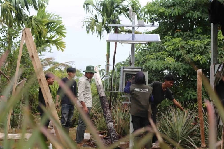
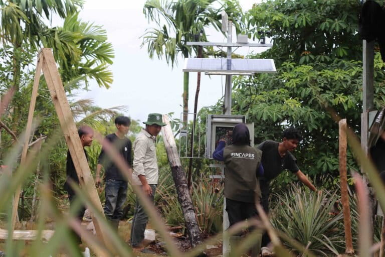
Recognizing the urgent need for a paradigm shift, the Fincapes project has introduced a proactive early warning system in the Air Merah Community Forest (HKm). By deploying low-cost, sensor-based devices, the initiative aims to empower local communities with real-time environmental data. These devices monitor critical metrics, including:
- Smoke and Temperature: Early detection of smoldering fires.
- Meteorological Data: Rainfall patterns and wind direction to predict fire spread.
- Soil and Water Metrics: Soil moisture and water table levels, which are the primary indicators of fire risk.
When conditions reach a critical threshold, the system triggers an automated siren, providing local communities with the window of opportunity needed to intervene before a small fire escalates into a landscape-level disaster. This data is also accessible via a web portal, ensuring transparency and enabling regional authorities to coordinate their responses more effectively.
Towards a Model of Community-Based Restoration
Beyond technology, active restoration is the cornerstone of the strategy for Sungai Gelam. The project has initiated the restoration of 47 hectares of degraded land, focusing on the integration of native peatland flora into existing agricultural systems. By intercropping species such as jelutung rawa (Dyera lowii), balangeran (Shorea balangeran), and pulai (Alstonia scholaris) with local areca nut and pineapple crops, the project promotes an agroforestry model that is both economically viable and ecologically resilient.
With a target of 80,000 seedlings to be planted under various agroforestry frameworks, the initiative aims to transform Sungai Gelam into a template for community-based peatland restoration by 2028. This model recognizes that the residents—who are the first to suffer the consequences of the haze—are the most effective stewards of the land, provided they are equipped with the right tools and knowledge.
Policy Implications and the Path Forward
The crisis in Jambi serves as a sobering reminder of the limits of human intervention in natural systems. When land use policies prioritize short-term economic gains—such as palm oil production—at the expense of hydrological stability, the long-term cost is often borne by the public in the form of respiratory health crises, biodiversity loss, and the immense financial burden of fire suppression.
Effective peatland management requires a multi-stakeholder approach that transcends administrative boundaries. This includes:
- Enforced Hydrological Management: Mandating the construction of canal blocks and water retention structures before the onset of the dry season.
- Community Empowerment: Supporting local monitoring networks and agroforestry initiatives that provide alternatives to land clearing via burning.
- Scientific Integration: Incorporating climate modeling into land-use planning to ensure that development does not outpace the ecosystem’s carrying capacity.
As Jambi moves toward 2028, the success of the Sungai Gelam project will be measured not just by the hectares of land restored, but by the extent to which it successfully alters the human relationship with the peat landscape. For the people of Air Merah, who have spent years living in the shadow of potential disaster, the ability to detect a threat before it ignites is more than just a technological upgrade—it is a vital step toward reclaiming their future from the cycle of fire.
The path ahead is undoubtedly steep. Restoring the ecological integrity of a landscape that has been fragmented by industry and drained of its lifeblood is a process that will outlast the current political cycles. However, the synthesis of indigenous knowledge, modern sensor technology, and sustainable agroforestry offers a viable blueprint. If the lessons from the 2026 fires are heeded, the thin plumes of smoke in the distance may, in the future, be recognized as a call to action rather than a prelude to a tragedy.

